Posts

Showing posts from February, 2015

Pińczów

Image
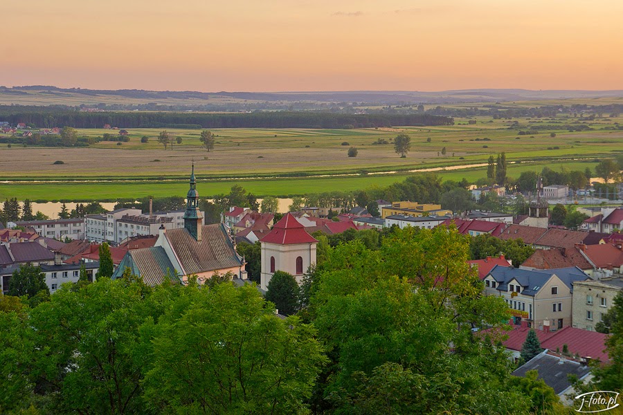
The centre of the city: view from St.Anna's Hill. Former Pauline Monastery Pińczów is one of the oldest and most historically meaningful cities in Poland. The city lies in the Świętokrzyskie Voivodeship, on the banks of the picturesque Nida river valley. This region is named Ponidzie (Nida Riverside). Ponidzie, which lies halfway between historic centers of Lesser Poland, Kraków and Sandomierz, in the late Middle Ages, it was one of the most important regions of the Kingdom of Poland. This gentle area, full of undulant hills, fertile soils and cut with the meanders of the Nida River, was the most densely populated part of Poland. The town charter of Pińczów was guaranteed by King Władysław Jagiełło on September 21, 1428. The Mirów district: view from St.Anna's hill. Former Franciscan Monastery The main attractions of the city is the beautiful complex of the former Pauline monastery, founded in 1449. In Pińczów's district of Mirów is located former Franciscan

Tuchola Forest National Park

Image
Nierybno Lake The Tuchola Forest National Park (Park Narodowy "Bory Tucholskie") is located in the heart of the Tuchola Forest , the largest woodland in the northern part of Poland. Park is small (46.13 square kilometres) but it is surrounded by a larger protected area called Zaborski Landscape Park. The Park forms the core of the Tuchola Forest Biosphere Reserve (UNESCO). The area was formed during the last glacial age and is covered with low hills, fields of glacial sands, and post-glacial lakes. Seven Lakes Stream The borders of the park cover only the area of the Seven Lakes Stream watershed (Struga Siedmiu Jezior). There are more than 20 lakes in the Park, numerous forests, meadows and peatlands. In the lakes and rivers live 25 species of fish. There are around 144 species of birds, including crane and eagle owl and wood grouse - the symbol of the park. A particularly important part of fauna are bats. Rhododendron tomentosum Harmaja in the bog woodl

Snowy morning on the Royal Route in Warsaw

Image
Krakowskie Przedmieście Street has an important role in the history of Poland, that’s why the street was deliberate destructed by Nazis during the World War II, especially following the Warsaw Uprising in 1944. After the war, the street was partly reconstructed. Visitationist Church Holly Cross Church At the beginning of the 21st-century street has been redesigned. Reconstruction was inspired by historical sources and Bernardo Bellotto's hyper-realistic paintings of the 18th-century street to give the area a look that is both old and modern. Nowadays it is the most beautiful and most prestigious street in Warsaw. Hotel Bristol Linked to: Krakowskie Przedmieście Street

Krakowskie Przedmieście Street, Warsaw

Image
Staszic Palace and the Nicolaus Copernicus Monument Krakowskie Przedmieście is one of the best known and most prestigious streets of Warsaw. This beautiful street is the part of the Warsaw's Royal Route, which connects the Old Town and the Royal Castle with King John III Sobieski's 17th century Wilanów Palace. Krakowskie Przedmieście is surrounded by historic palaces, churches and manor-houses. There are located some of the most notable institutions in Warsaw – the Presidential Palace, Warsaw University, and the Polish Academy of Sciences headquartered in the Staszic Palace. Czetwertyński Palace, Tyszkiewicz Palace (Uniwersity of Warsaw) and the Bristol Hotel Uniwersity of Warsaw, main gate Linked to: Saxon Garden ABC Wednesday

Saxon Garden, Warsaw

Image
The Saxon Garden - Warsaw's oldest public park - is located within 10 minutes' walk from the old town. The Saxon Garden was originally the site of Warsaw fortifications, "Sigismund's Ramparts". The garden was extended in the reign of King Augustus II, who attached it to the "Saxon Axis", a line of parks and palaces linking the western outskirts of Warsaw with the Vistula River. The park was opened to the public on 27 May 1727. It became a public park before most world-famous parks and gardens. The Saxon Garden initially was a Baroque style park, inspired by the park of Versailles. In the 19th century, it was turned into a Romantic English-style landscape park. During World War II park was destroyed, especially after the Warsaw Uprising. It was partly reconstructed after the war. In the park are located 20 beautiful sandstone statues. They were made before 1745 by anonymous Warsaw sculptors under the direction of Johann Georg Plersch. In th

Willow riparian forests

Image
This softwood floodplain forest type occurs along large lowland rivers. It is dominated open willow and willow-poplar riparian forests dominated by the arborescent species Salix alba. This vegetation type develop also as stages of secondary succession on abandoned flooded meadows and in other wet habitats in the floodplains. The stands were historically affected by regular spring floods. They have become rare after streamflow started to be regulated in the end of 19th and first half of the 20th century. Linked to: Misty beech forest #1 , Misty beech forest #2 , Through the mist ,  Carpathian beech forests ,  Mountain forest ,  Chestnut tree

Darmstadt

Image
Darmstadt is a city in the Bundesland (federal state) Hesse in Germany. The origins of the name are unknown. The name Darmstadt first appears towards the end of the 11th century, then as Darmundestat. Literally translated, Darmstadt means "Intestine City", but this is just a coincidence. Locals often believe, that the name derives from the 'Darmbach' (a small stream formerly running through the city). In fact the stream received its current name much later, after the city. Darmstadt was the capital of an independent country (the Grand Duchy of Hesse). The ducal palace of Darmstadt is located in the city centre. Architecture of Darmstadt has been influenced by British and Russian imperial architecture with many examples still existing, such as the Luisenplatz (the central square of the city) with its 33-metre column commemorating Ludwig I (called Langer Lui, meaning Long Ludwig), and the old Hessian State Theatre. Darmstadt was a centre of the Art Nouveau

Jewish Cemetery in Grodzisk Mazowiecki, Poland

Image
The Jewish cemetery in Grodzisk Mazowiecki, central Poland, was established in the 18th century. During World War II the Nazis devastated the cemetery, and the tombstones were used for construction works. In the days of 12-20 February 1941 the Jews taken away to Warsaw in the subsequent transports were sent to the death camp in Treblinka. The devastation process of cemetery was continued also after the War. Restoration and reconstruction of the Jewish Cemetery in Grodzisk was made possible not until 1988. On February 27, 1996, the cemetery was entered in the Register of Historic Monuments. The necropolis is located on a prolonged rectangular plot. What has survived until today are over 200 matzevot or their remnants. The tombstones date back to the turn of 19th and 20th centuries. Some of them also date back to the 1st half of the 19th century or World War II. The matzevot are made mainly of sand blocks, crowned with a half-round arch. The inscriptions are mainly in Hebrew.

Spisz Region

Image
North part of the Spisz Region Spisz (Slovak: Spiš,  Polish: Spisz) is a region in north-eastern Slovakia (3,500 km²) and in south-eastern Poland (195.5 km²). The Spisz has been endowed by a really beautiful nature. Its northern part is surrounded by massive peaks of the High Tatras mountains and the Belianske Tatras,  that merge with the unique scenery of the National Park Pieniny with the Dunajec river. The eastern border is Levoča Mountains (Levočské vrchy). In the south, there is Slovenské Rudohorie mountain range followed by picturesque cliffs and gorges of the National Park Slovak Paradise. North part of the Spisz Region and the Tatra Mountains - a view from Wysoka (Pieniny Mts.) The Spisz has always been a melting pot of many nations, cultures and religions. You would find here people of the Roman-Catholic as well as the Greek-Catholic religion, Orthodox, Evangelic and Jews. They worked and lived together. The Very interesting ethnic group are the Highlanders. They

On the slopes of Rysianka

Image
Wind-damaged trees on the slopes of Rysianka, Żywiec Beskids, Poland. Linked to: Settlement in Beskidy Mountains ,  Żywiec Beskids (continuation) ,  Żywiec Beskids ,  Rysianka Mountain Pasture  and  Peaks of Żywiec Beskids

Settlement in Beskidy Mountains

Image
Hamlet of Zapolanka in the Żywiec Beskids Specific character of natural environment in mountainous areas greatly determines human activity including settlement and land-use. The most significant population increase in the Polish Beskids took place between the First and Second World War. Deforestation, a  process concurrent to expanding agriculture, was almost over by the end of the 19th century and the first part of 20th century. After World War II has occurred depopulation of most villages. This is attested by an increase of forested area in the region. Present land-use pattern is optimal and no further interferences are necessary in order to retain all of the natural and cultural values of this region. Hamlet of Zapolanka in the Żywiec Beskids Hamlet of Kręcichłosty in the Żywiec Beskids Linked to:  Żywiec Beskids (continuation) ,  Żywiec Beskids ,  Rysianka Mountain Pasture  and Peaks of Żywiec Beskids

Radziejowice Palace

Image
Radziejowice is a village in east-central Poland. It is situated in the lightly hilly and picturesque terrain of Mszczonów Heights. In the 15th the powerful Radziejowski family built their residence here. In 17th century Renaissance manor acquired the shape of a baroque palace complex. Primate Michael Radziejowski finished rebuilding a wing from the original palace configuration which presently constitutes a section of the palace complex. The palace were surrounded with spacious gardens. After the Primate’s death Radziejowice belonged to the Prażmowski family and subsequently Ossoliński family, and then in the end of 18th century came into possession of the Krasińskis. Krasińskis transformed the palace into its present classical form. In the 19 th century the palace interiors were decorated with paintings. Next to the main palace were built the small neo-gothic romantic tower and a landscape park were created around the palace. Some pieces of tower (so-called Little Castle) origina

Sanniki - Fryderyk Chopin European Art Centre

Image
Sanniki is a village in east-central Poland. It lies approximately 79 km west of Warsaw. There is a beautifully situated and renovated palace. The palace is concealed among splendid old trees in a extensive park and is surrounded by a white wall. This estate belonged to Aleksander Pruszak. Sanniki Palace acquired its present form in 1910, to a design by Władysław Marconi. Władysław Marconi was a famous Warsaw architect who designed the beautiful Hotel Bristol in Warsaw ( click to see ) and a lot of palaces and tenement houses. Into the front wall of the palace tower is a marble plaque with the following inscription: 'In this manor house Fryderyk Chopin stayed in 1828'. Fryderyk Chopin, the famous Polish composer, vacationed here in July and August 1828. In 1981 a Fryderyk Chopin Memorial Centre was created in the left wing of the palace. Currently is there the F. Chopin's European Art Centre. (Learn more: Chopin's Poland ) You might also like other article
Related Posts Plugin for WordPress, Blogger...

Most Recent Articles

See Also