Posts

Showing posts from 2015

Tatra Mountains #4

Image
Tatra Mountains and Levoča Mountains - Autumn view from the slopes of Małe Pieniny Mountains

Merry Christmas!

Image

Małe Pieniny at dusk

Image
The Małe Pieniny (Small Pieniny) mountain range  is a picturesque area in the south of Poland and is a eastern part of Pieniny Mountains. The name appeared only in the mid-nineteenth century, in documents of the eighteenth century there was the name of Szlachtowskie Mountains. The Small Pieniny are higher than the main part of mountain range, but their western part rolls down softly towards the Dunajec river valley and produces an illusion of “smallness” – hence the name.

Small Pieniny Mountains (Małe Pieniny)

Image
Small Pieniny Mountains (Małe Pieniny) are the eastern part of the Pieniny band. The highest peak of Small Pieniny, who is also the highest in the whole of the Pieniny Mts., is also known as High Rocks (1052 m a.s.l.). There are many limestone hills of sharply outlined forms and bare walls. In the eastern part of the rocky nature gradually disappears and the peaks begin to resemble a typical Beskydy hills. Southern slopes are steeper than the north, and these are cut by valleys, which are broad in its headwaters area, but narrow at the mouth. Vegetation here is more limited than in other parts of the Pieniny, had in fact been strongly transformed by human activity. There are numerous meadows and pastures in the eastern part of growing forests, mainly spruce, also caused by human activity.  Small Pieniny are an attractive area for hiking, biking and skiing. The entire ridge of the Small Pieniny leads the blue trail. The route is very attractive landscape in most outdoor areas d

Tatra Mountains #3

Image
Tatra Mountains and Levoča Mountains - Autumn view from the slopes of Małe Pieniny Mountains

Tatra Mountains #2

Image
Tatra Mountains - Autumn view from the slopes of Wysoki Wierch (Małe Pieniny Mountains)

The Centennial Hall in Wrocław

Image
The Centennial Hall (Polish: Hala Stulecia) in Wrocław (Poland) was constructed according to the plans of architect Max Berg in 1911–1913, when the city was part of the German Empire. The cupola was made of reinforced concrete, and with an inner diameter of 69 m and 42 m high it was the largest building of its kind at the time of construction. The symmetrical quatrefoil shape with a large circular central space seats 7,000 persons. The Hall became a key reference for the development of reinforced concrete structures in the 20th century. In 2006 the building was listed as a UNESCO World Heritage Site.  The Centennial Hall lies close to popular tourist attractions, such as the Wrocław Zoo, the Japanese Garden, and the Pergola with its Multimedia Fountain and is frequently visited by tourists and the local populace.

Tatra Mountains - panorama

Image
Panoramic view of the Tatra Mountains (Slovakia) Click to view original image size

Tatras

Image
Tatra Mountains - Spring view from the slopes of Jaworzyna in the Gorce Mountains

Island Beskids

Image
The Island Beskids (Polish: Beskid Wyspowy) is a mountain range in southern Poland. The distinctive feature of this region is its isolated, individual peaks, from which derives its name. The highest peak is Mogielica (1170 meters).

Return to the Isle of Skye

Image
The Isle of Skye is the largest island of the Inner Hebrides of Scotland. It is famous for its scenery and landscapes that will take your breath away. The coastline of Skye is a series of peninsulas and bays radiating out from a centre dominated by the Cuillin hills. The Black Cuillin is some of the most dramatic and challenging mountain terrain in Scotland. Waterfalls, mountains, glens..., the diversity of the landscape is matched by the diversity of weather. The Island is also great destination for Wildlife watching. The Island of Skye is an incredibly beautiful part of the world and one of the top locations in Scotland to visit. 

Old Town Hall of Wrocław - architectonic details

Image
See:  Old Town Hall of Wrocław , Wrocław - The Meeting Place

Old Town Hall of Wrocław

Image
The Old Town Hall of Wrocław is one of the largest town halls in Poland. It stands at the center of the city’s Market Square and is one of the main landmarks of the city. Wrocław Town Hall is a fine example of bourgeois Gothic architecture. The building was developed over a period of about 250 years, from the end of 13th century to the middle of 16th century. The Old Town Hall's long history reflects developments that have taken place in the city since its initial construction. The structure and floor plan changed over this extended period in response to the changing needs of the city. The current form with ornaments on the Eastern and Southern facades dates from the late 15th. The Old Town Hall is famous for its astronomical clock from 1580 and the 66 metre high tower. The building escaped relatively unscathed after World War II. After reconstruction work, in years 50th, it was re-opened as the Museum of Burgher Art. Tourists are allowed to see the splendid Gothic interi

Wrocław - The Meeting Place

Image
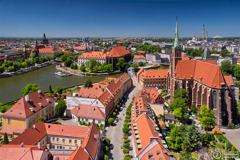
The city of Wrocław originated at the intersection of two trade routes, the Via Regia and the Amber Road. At various times in history, it has been part of the Kingdom of Poland, Bohemia, Hungary, the Austrian Empire, Prussia, and Germany. Wrocław is the historical capital of Silesia and Lower Silesia. Today, it is the capital of the Lower Silesian Voivodeship, Poland. Wrocław is the modern and dynamic city. It is classified as a global city by GaWC, with the ranking of high sufficiency and living standard. Wrocław was among 230 cities in the world in the ranking of the consulting company Mercer - "Best City to Live" in 2015. It is also in the top ten places to visit in the ranking of the British newspaper The Guardian. In 2016, the city will be the European Capital of Culture and the World Book Capital.  Wrocław is full of attractions. Most of the city's main tourist attractions are located directly in the center. Most of them is accessible by foot. The oldest,

Hiking on Mount Wank

Image
The Wank is a mountain in the southwestern Ester Mountains range near Garmisch-Partenkirchen, Germany. It rises to 1,780 metres a.s.l. The summit is a popular destination for hikers, day-trippers from Garmisch-Partenkirchen. The Wank is linked to Garmisch-Partenkirchen by a cable car system called the Wankbahn.  Nearby is an scientific measuring station and the Wank-Haus, a mountain hut that provides food and accommodation to visitors. The grassy summit offers spectacular views across the region, which provide the best view of Garmisch-Partenkirchen and a complete panorama of the Zugspitze and the Wetterstein mountain range.  The summit is a popular destination for gliders and paragliders, who are able to take advantage of its strong thermals to make exceptionally long flights.

Lake Charzykowskie at dusk

Image
Charzykowy - a small village near Chojnice, thanks to location directly on Lake Charzykowskie has become a mecca for sailors not only polish but also from the world. The village has a well developed range of accommodation and catering. Unfortunately, during peak summer season, when the place is teeming with life to find accommodation without much prior reservation is bordered on the miraculous. Tourists can use the swimming, while the sailors are able to berth and enjoy the summer sunsets in the safe water harbor.

Sails on the Lake Charzykowskie

Image
Lake Charzykowskie is located in the macro region of South Pomeranian Lake District, within the western part of Tuchola Forest and within the area of Zaborski Landscape Park; it touches the western limit of Tuchola Forest National Park. Since June 2010 it belongs to a buffer zone of Tuchola Forest Biosphere Reserve (MAB-UNESCO) (source: Eulakes ) ABC Wednesday

Forests in Tuchola Forest Biosphere Reserve

Image
Tuchola Forest Biosphere Reserve covers one of the largest forests in Poland, containing mainly Scots pine (Pinus sylvestris). The landforms of the area were sculpted by a glacier that retreated at the end of the last glacial age creating characteristically long ribbon lakes. Additionally there are large clusters of inland sand dunes. There are extensive areas of peat bogs formed as a result of the overgrowing of the shallower lakes.  The most valuable part of the biosphere reserve (core zone) is " Tuchola Forest " National Park and 25 nature reserves. A buffer zone consists: Wdzydze Landscape Park , Zaborski Landscape Park, Tuchola Landscape Park and Wda Landscape Park. (Source: Nature reserves in Poland ) ABC Wednesday

Charzykowskie Lake: End of season

Image
Charzykowskie Lake is located in the Tuchola Forest, near the "Tuchola Forst" National Park border, and in the Zaborski Landscape Park. It is located also in the MAB Biosphere Reserve.  Lake Charzykowskie is a true paradise for water and water-sports enthusiasts. The lake hosts numerous sailing events, e.g. regattas and youth training camps The sailing traditions of the lake and its water sports centres date back to the interwar period, when Charzykowskie Lake was the heart of Polish water sports. Charzykowy – a village located by the lake – still house the oldest Polish sailing club. Today Charzykowy has a yacht harbour equipped with a modern infrastructure, along with devices for launching vessels. ABC Wednesday
Related Posts Plugin for WordPress, Blogger...

Most Recent Articles

See Also