Posts

Showing posts from October, 2016

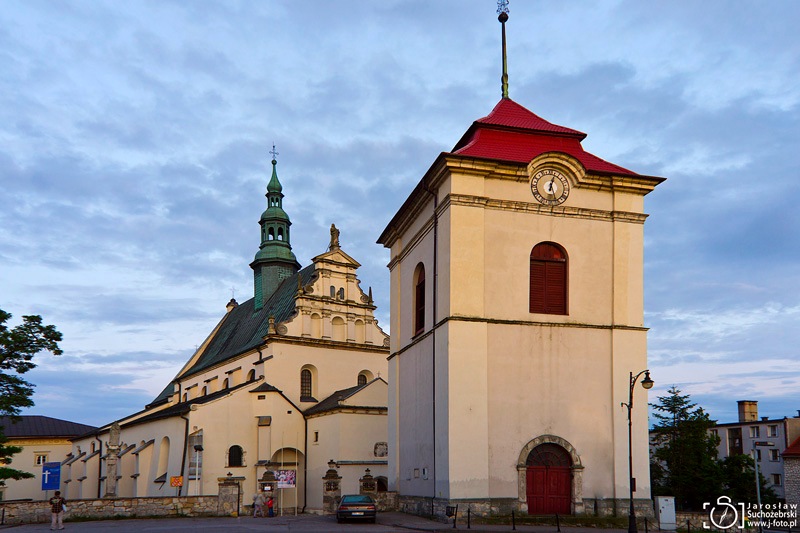
Churches in Pińczów, Poland
Image
The first parish church was in Wierciszowo (a quarter of the city of Pińczów nowadays). In the thirties of the 15th century Bishop of Cracow, Zbigniew Oleśnicki founded a brick parish church in Pińczów. In 1449 it was erected Pauline. Monastery and the parish church was incorporated into the newly established monastery. The parish church was rebuilt completely approx. 1642. The Paulines Monastery was closed in 1819. The Church of St. John the Evangelist has three naves. At the south aisle, there is a Chapel of Angels from the beginning of the 17th century. The main altar was built approx. 1744., And nine side altars was created in the first half of the 18th century. Today in the former Baroque monastery of the Order of Saint Paul the First Hermit the Regional Museum in Pinczów is located.  The Museum's collections come from Ponidzie and document the traditions, history and culture of the region from the earliest times to the present day. Church and mon...

St Anne's Chapel in the city of Pińczów, Poland

Image
St Anne's Chapel in the city of Pińczów in Poland was designed by Santi Gucci and was financed by a local noble, Zygmunt Myszkowski   (read more about  Pińczów ) .  Italian architect Sante Gucci, were one of the most successful and fruitful artists of Renaissance. He had his workshop in Pińczów.  Some of his most notable works are: the integral design and funerary monuments in the Sigismund's Chapel in the Wawel Cathedral in Kraków, the castle in Janowiec on the Vistula river, and the palace in Książ Wielki. St Anne's Chapel was the first in Poland freestanding chapel dome with only a cult destination. The small temple was built in 1600, on the slopes of the St. Anne's Hill overlooking the town. The hill on which stands a chapel is located north of the city centre, opposite the castle hill. In the past, the chapel was surrounded by fortifications and was part of the fortification system of the Pińczów castle. The chapel is built from a loca...

Mirów - romantic quarter of city of Pińczów, Poland

Image
Mirów - former town - today is a quarter of city of Pińczów in Świętokrzyskie Voivodeship, Poland (read more about Pińczów ). Mirow was founded on July 1, 1592 by the Margrave Zygmund Gonzaga Myszkowski as New City Mirow. Myszkowski began the construction of the church, which was completed by his son Ferdinand after the death of Margrave. In 1612 Mirow was incorporated into the neighboring city of Pińczów. At the turn of the 17th and 18th century, the Reformers monastery was founded next to the Mirów collegiate. Since 1906 in the part of the monastery buildings is the hospital located. Largest tourist attractions of Mirów is the Renaissance church of Reformers, located at the former Mirów Marketplace. It is the one-nave construction built on a cruciform plan. There are  two chapels on both sides of the aisle. Next to the church is located Renaissance tenement house from the turn of the sixteenth and seventeenth century. The first owner of the house was...

Lake Wdzydze - "Kashubian Sea"

Image
Kashubian sea - so Kashubians called one of the most beautiful Polish lakes - Wdzydze. It is located in Tuchola Forest (read more: Forests in Tuchola Forest Biosphere Reserve ), in the region of South Kashubia, in the Pomeranian Voivodeship. Lake Wdzydze (Kashubian: Jezoro Wdzëcczé), also known as the Big Water and Szerzawa holds the five lakes: Wdzydze, Radolne, Gołuń, Jelenie and Słupinko. These lakes form a gutter system in the Lake Wdzydze cross with sides of lengths 9 and 11 km and the surface of 1455.6 ha and a maximum depth of 71.4 m. That body of water has the 21st position in terms of area among the Polish lakes (read more about Polish lakes ). The Wdzydze lake system has as many as ten islands. In the lake, which does not have a full connection with the Baltic Sea, lives the endemic fish brown trout, which spawn in the surrounding rivers. Lake Wdzydze is a central part of Wdzydze Landscape Park. The Park was created in 1983, to protect natural, cultural an...

Lovely October morning in Ogonki in the Kashubia, Poland

Image
Ogonki (Kashubian: Ògónczi) is a small Kashubian village in northern Poland, 56 km west of the Gdańsk - capital of the Pomeranian Voivodeship. The village lies approximately 30 km south-west of Kartuzy. The village is located by the beautiful Lake Sumino (see: Lake Sumino on the Charzykowska Plain, Poland ) and is surrounded by green pine forests. You can arrive in Ogonki only through the sandy unpaved road. There live only 20 permanent residents, but in the vicinity of the lake is a few dozen holiday cottages, so here it is quiet and peaceful. This is the perfect place to unwind in the open. You might also like: Kashubia - region of beautiful lakes and green forests This article id linked to:

Kashubia - region of beautiful lakes and green forests

Image
Kashubia (Polish: Kaszuby, Kashubian: Kaszëbë) is a language area in the historic Eastern Pomerania region of northwestern Poland. The region is home to the Kashubian Lake District. Kashubia is a wonderful place - according to the legend created by God, through the intercession of Angels and with the help of the Griffin.Legend has it that during the creation  of the world God left a large sandy area, scanty in forests and lakes, in which there was no life. At the request of His helpers, the Angels, He looked in His magic bag to check whether He could give something more to this place, and by tilting the bag He provided the previously-barren Kashubia with numerous green forests, beautiful meadows covered with flowers, rivers and lakes with water so pure that one could see in it like in a mirror, and fields with soil so fertile that every year it produced abundant crops. To make sure that nothing would disappear from such a wonderful place, God sent the Griffin to guard thi...

Lake Sumino on the Charzykowska Plain, Poland

Image
Charzykowska Plain is a physico-geographical mesoregion in northern Poland in the province of Pomerania. The name comes from the Charzykowy village (read more: Lake Charzykowskie at dusk ). According to the geological structure, Charzykowska Plain is a postglacial sandur i.e. a thick layer of sand and gravel deposited around 12-14 thousand years ago when the last glacier was melting. The relief of the region was formed during the last ice age. In addition to the moraine hills, there are also sandurs, ribbons, sand dunes and river valleys (read more: Forests in Tuchola Forest Biosphere Reserve ). Among the forests, tourists will find numerous lakes, including 40 lakes exceeding an area of 1 km², e.g.  Charzykowskie Lake .  On the northeastern end of the Charzykowska Plain is located Lake Sumino. It is a beautiful glacial lake with a clean water and very varied shoreline. The lake's total area is 1.52 km² and the maximum depth is 15.9 m. Read other posts a...
Related Posts Plugin for WordPress, Blogger...

Most Recent Articles

See Also