Posts

Showing posts from 2014

Peaks of Żywiec Beskids

Image
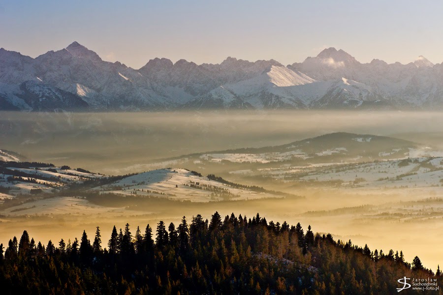
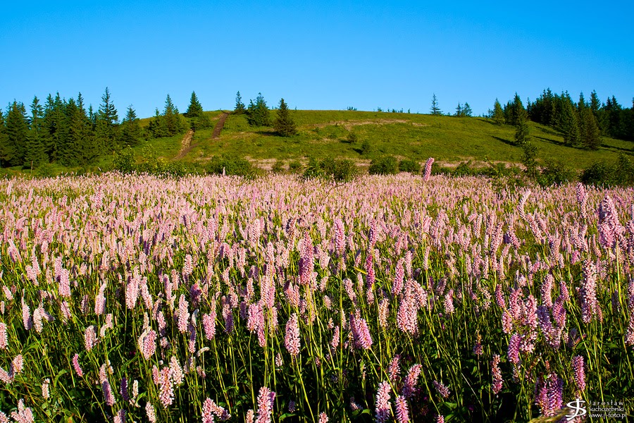
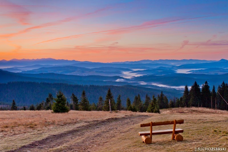
A view from the Pilsko mountainside towards the western part of Żywiec Beskids The Żywiec Beskids became a tourist destination in earnest a century ago. Tourists were very quick to recognize the advantages of the highest peaks Babia Góra (1,725 m above sea level) and Pilsko (1,557 m a.s.l.). Nowadays, they are the most popular hiking, cycling and skiing destinations. From the both peaks we can admire a vast panorama. Mountains attires itself in various garments: white, enveloped in snow in winter; woven from light green leaves in spring; green, interwoven with colourful flowery spots in summer and in autumn, made of golden leaves. A view from the peak of Sokolica towards the Babia Góra massif Linked to: Żywiec Beskids (continuation) , Żywiec Beskids and Rysianka Mountain Pasture

Ponds in Adamów

Image

Gorce glades

Image
Gorce mountains are a part of the Western Beskidy Mountains. The Gorce Mountains culminate in Mount Turbacz, rising to a height of 1,310 m above sea level. Mount Turbacz is a hub of several ridges, which are separated by deep valleys. The landscape of Gorce has been altered by human activity. Early settlers appeared in the Gorce area in the 12th century. The forests suffered most in the 19th century during the imperial rule of Austria-Hungary. Trees were cut on a large scale, especially in easily accessible areas. Some glades, located on ridges, were used as mountain pastures until recently. Today the picturesque and charming glades enrich the biodiversity and landscapes. (Lern more: The Gorce National Park ) Linked to: Pieniny meadows (continuation) , Pieniny meadows ,  Mountain meadows ABC Wednesday

Errant Rocks (Table Mountains)

Image
The Errant Rocks ("Błędne Skały") reserve is located in the Table Mountains and it is a part of the Table Mountains National Park. The plateau is a denudation monadnock formed in the top part of the Upper Cretaceous sediment (Sandstone). The sandstones are cut by three very regular joint systems, 6-8 m deep and widened by weathering and erosion. These processes led to the formation of rock labirynth along which the tourist trail was developed. This fairy tale land is impressive in the amount and variety of its rock formations and draws tourists to its mysterious labyrinths and enchanting atmosphere. There are several notable rock formations, eg. the Hens’ Foot Rock (see photo above) (Learn more: The Errant Rocks ) Linked to: Table Mountains

Mountain trail

Image

Niedzica Castle

Image
Niedzica Castle also known as Dunajec Castle is located in the southernmost part of Poland in Niedzica (Pieniny Mountains). The castle was erected in 14th century and for centuries was a border-post with Hungary. Nowadays the castle is used as a museum. Niedzica Castle is located, on a hill 300 m upstream from the Dunajec River mouth, measured from the center of the dam on Czorsztyn Lake. Czorsztyn Lake, was created in 1994 by damming the Dunajec River downstream of the castle. The castle now stands approx. 30 m above the upper water level. The castle is a great place to visit. It is known as one of the most picturesque castles in Poland. The views are magnificent, particularly to the south over the Pieniny mountains. Linked to:  Pieniny Meadows , Pieniny Meadows (continuation) ,  Spisz's Pieniny  and  Three Crowns You might also like other articles about most beautiful  Polish castles and palaces (click) ABC Wednesday

Pieniny meadows (continuation)

Image
Linked to: Pieniny Meadows ,  Spisz's Pieniny  and  Three Crowns

Look at the Tatra peaks

Image
The Tatra Mountains are highest mountain range of the Karpaty Mountain and form a natural frontier between Slovakia and Poland. The Tatra Mountains occupy an area of 785 square kilometres and are the smaller Alpine Mountains in Europe. The highest peak called Gerlach (2,655 m.a.s.l.) lie in Slovakia. The Tatra Mountains are divided into the West Tatra and East Tatra Mountains. The East Tatra Mountains are further divided into the High Tatra and Belianske Tatra Mountains. The Tatras are protected by law by the establishment of the Tatra National Park with membership in the World Network of Biosphere Reserves of UNESCO. (Learn more: Poland Travel ) Linked to: Tatra Mountains and  Tatra Mountains #2

Pieniny meadows

Image
The meadows in Pieniny mountains are not natural but they constitute a very important element of the landscape. They are colourful, rich in species and highly diversified. In a single square metre one can find about 30-40 species of flowering plants. There are many orchids and other interesting flowers and plants. The best month to see them is June. The meadows, due to their species diversity and richness, provide thousands of stenothermal and photophilous insects with a plentiful supply of food. The Pieniny meadows are famous for abundance of butterflies; the best known one is the Mountain Apollo, which can be found only here. (Learn more: Pieniński Park Narodowy ) Linked to:  Spisz's Pieniny  and Three Crowns

Three Crowns

Image
A view from the summit of Three Crowns towards the Dunajec river valley   Pieniny is a mountain range in the south of Poland and the north of Slovakia. The Pieniny range is 35 km long and up to 5 km wide. The two gorges of the River Dunajec divide them into three parts: Spisz Pieniny, Small Pieniny and the Proper Pieniny. Pieniny’s highest peak – Wysoka (Polish) / Vysoké Skalky (Slovak) – reaches 1,050 metres above sea level (Small Pieniny), but the most famous peak is Trzy Korony (Three Crowns - 982 metres a.s.l. - Proper Pieniny). It is also the summit of the Three Crowns Massif (Proper Pieniny).  The Pieniny mountains are mainly built from limestone and they create picturesque and impressive, almost perpendicular walls which go down towards the Dunajec River.  Already in the 19th century some people noted that the area should be protected. The Polish Pieniny National Park and the Slovak National Natural Reserve in Pieniny was the first International Landscape Park in Eur

Mountain meadows

Image
Bistorta officinalis, commonly known as bistort or European bistort, is a species of flowering plants in the dock family Polygonaceae. It is typically found growing in moist meadows e.g. extensively used mountain meadows ( Polygono-Trisetion & Arrhenatherion ). Extensively used meadows in the Żywiec Beskids Extensively used meadows in the Żywiec Beskids

Autumn morning in Ujsoły

Image
  Ujsoły is a village in Żywiec Beskids, in southern Poland, close to the border with Slovakia. The settlement Ujsoly was founded in the sixteenth century by Walachian settlers - pastoral peoples of the Balkan origin. The newcomers settled on the uninhabited mountain areas. Original name of the village was "U Soły" (eng. "by the Soła") and is derived from the position of the first homesteads located directly by the River Sola. Over the years the name were Polonized to the currently used name "Ujsoły". Ujsoły is the perfect starting point of many mountain hiking trails.

Żywiec Beskids (continuation)

Image
A view from Rysianka Mountain Pasture towards the Tatra Mountains A view from Rysianka Mountain Pasture towards the south Linked to:  Żywiec Beskids and Rysianka Mountain Pasture

Żywiec Beskids

Image
A view from Rysianka Mountain Pasture towards the Mt. Babia Góra Żywiec Beskids (Polish: Beskid Żywiecki) located in the southwest of Silesia along the Slovak border, are among the tallest mountains in Poland after the Tatra Mountains. The highest peak is Babia Góra (1725 m a.s.l.). Tourist trails run through magnificent forests and glades from which enfolds a fascinating view over the Tatras and even Little Fatra in Slovakia. A view from Rysianka Mountain Pasture towards the Little Fatra Mountains Linked to:  Żywiec Beskids (continuation) and Rysianka Mountain Pasture

Lake Frillensee

Image
The Frillensee is a small lake in the Wettersteingebirge mountains near the Eibsee. The landslide separated the Frillensee from the Eibsee. However, both lakes are still connected underground and the water level has always the same height. The name is derived from minnow ( Phoxinus phoxinus ) - a small freshwater fish (germ. die Pfrille ).

Drwęca Lake in Ostróda

Image
Ostróda's advantageous location makes the town rich in attractions relating to active relaxation. City is nicknamed “The Pearl of Masuria”. Here is the central port of the network of three canals: the Ostróda-Elbląg Canal, Ostróda-Stare Jabłonki and Ostróda-Iława. The most famous one is the Ostróda-Elbląg Canal that is equipped with a system of slipways making it possible to sail a ship on... the land. The Canal was built in the middle of the 19th century and joined the Drwęca Lake (Ostróda) with the Druzno Lake (Elbląg). Canal, being the only one object of its kind in Europe, is the main tourist attraction of the region. At Lake Drwęca, water sport lovers may use an 800 m water ski lift, a professional canoe track and a town beach with a water sports equipment rental. Tourists cannot overlook yet another attraction, namely the biggest inland pier in Poland. Linked to: Drwęca Lake shore path

Drwęca Lake shore path

Image
The town of Ostróda evolved at the site of an original Old Prussian settlement where the Drwęca river flows into Lake Drwęca (Jezioro Drwęckie). The town name come from town Osterode am Harz in Lower Saxony, Germany (now a sister city with Ostróda). There are five lakes within the town limits and amongst fifteen lakes at a close distance.  Here is the central port of the network of three canals: the Ostróda-Elbląg Canal, Ostróda-Stare Jabłonki and Ostróda-Iława. All this makes Ostróda a dream place for those into water sports, sailing, biking, or wandering. Linked to: Drwęca Lake in Ostróda

Lake Eibsee in Bavaria

Image
Eibsee is a lake located in the highest altiutudine of Germany. It is considered one of the most beautiful lakes in the Bavarian Alps due to its location beneath the Zugspitze and the clear, green water. Lake name ( die Eibe in German = yew, der See = lake) is attributed to the yew, which grew formerly very numerous around the lake. Linked to: Eibsee SKYWATCH FRIDAY

Jewish Cemetery in Łódź, Poland

Image
The Cemetery at the Bracka Street in Łódź was established in 1892. There is the largest Jewish cemetery in Europe. Izrael Poznanski donated the first 10.5 hectares of land towards the establishment of a new cemetery. The outbreak of a cholera epidemic in 1892 forced the Russian authorities to give the final go ahead to establish the new cemetery. Thus, the first people buried there in the winter of 1892 were approximately 700 cholera victims. In 1893, 1,139 people were buried at the new cemetery. From 1893 to 1896, the basic construction of the cemetery was completed under the supervision of well-known architect Adolf Zeligson. Today about 160 000 people are buried there. The Cemetery has an area of 39,6 hectare. Many people meritorious for Łódź were buried at this Cemetery. Their tombstones often show high class of stone and metal craftworks. Also here are buried victims of one of the most tragic events in the history of the mankind - Holocaust. Learn more: www.Jewis

Golden Polish Autumn

Image
Golden Polish autumn – that’s the phrase commonly used to describe this season. In September and October the weather is often beautiful, sunny and warm. During this month a total change of colors takes place. Only coniferous trees retain their green color, other than that, the green disappears and gives place to bronze, red and yellow tones which create unique autumn aura. It is time to celebrate and enjoy the colors. Mandarin Orange Monday  - ABC Wednesday
Related Posts Plugin for WordPress, Blogger...

Most Recent Articles

See Also