Posts

Showing posts from September, 2016

Chlastawa. The Route of Wooden Churches of the Bagpipe Region, Poland

Image
The readers of the "National Geographic Traveler" magazine in the sixth edition of the "The seven new wonders of Poland" have picked "The Route of Wooden Churches of the Bagpipe Region" in the Lubuskie Voivodship. The Route is some 23 kilometers long and leads to the temples in Chlastawa, Klępsk and Kosieczyn. The most beautiful church is located in Chlastawa nearby Zbąszyń.  The Filial Church of the Birth of the Holy Virgin Mary in Chlastawa was erected in 1637 for Protestants persecuted in Silesia. The church was built in frame construction with wooden tower. The interior of the church in a unique form presents an open roof truss structure.  It is covered with rich polychrome from 17th century It presents the scenes of the Last Judgment and foliage motifs. The church in Chlastawa is a historical monument of outstanding universal value which should be particularly interesting for folk architecture lovers. Together with the gate-belfry an

Mikulov - fairy-tale town in South Moravia, Czechia

Image
South Moravia is a wine-growing region in Czechia. It is a true paradise for each and every tourist. In the very centre of the South Moravia is located the beautiful town of Mikulov. Mikulov is situated between the Pavlovské vrchy hilly area and the edge of the Mikulov Highlands, on the border with Lower Austria. Mikulov is a town you definitely shouldn’t miss on a journey through Czechia. Dominating the town is the highly conspicuous Baroque chateau, which it located atop a high cliff. The castle stands on a place of historic Slavonic settlement, where since the end of the 13th century the original stone castle was erected. The present castle is the result of a reconstruction in 18th century. It is the seat of the Regional Museum in Mikulov, housing art and historical collections, including artifacts relating to the history of local wine production. On the main square you can admire some ornately decorated houses and the imposing Dietrichstein Mausoleum. You can tak

Kamieńczyk Waterfall - the highest waterfall in the Polish part of the Karkonosze Mountains

Image
The highest waterfall in the Polish part of the Karkonosze Mountains (Giant Mountains) is Kamieńczyk Waterfall (Polish: Wodospad Kamieńczyka). Waterfall is very impressive all year round and it is a frequent target of the tourist hiking. It is located in the Karkonosze National Park, on steep northern slopes of mountains, on one of the trails leading from Szklarska Poręba to the summit of Szrenica. It is one of the most spectacular and rich in content geosites in the Giant Mountains. The water of the Kamieńczyk stream forms a three-level cascade 27 m high falling to the gorgeous Kamieńczyk Gorge. The gorge is about 100 m long with vertical, rocky walls reaching over 25 m in height while its width at some parts is less than 4 meters. Behind the middle waterfall cascade there is a cave called Golden Cave (Polish: Złota Jama) hammered by the Walloons (Medieval masters in excavating and processing natural minerals, iron ores, metals, precious stones and quartz) and famous for pegmatite

Castle of the Dukes of Mazovia in Ciechanów

Image
The castle in Ciechanów was built on the swamps of the Łydynia River on the turning point of the fourteenth and fifteenth century. It was erected by the Masovian Duke Siemowit III, and his son Janusz I, Prince of Ciechanów and Warsaw. The brick stronghold was built on the mound made of layers of clay and timber. The towers located in the four corners of the castle's square formation help to defend the stronghold, and additional 10 metre high defensive walls. In the fifteenth century, the castle was raised by an additional level and a raised courtyard. The castle as the prince’s headquarters had defensive, economic, administrative and judicial roles.  After the death of the last duke of Mazovia, in the second half of 15th century, Mazovia was incorporated into the Polish state. In 1547, when the castle belonged to Polish queen Bona, the stronghold changed its function into an aristocratic residence. In later years, the building fell into disrepair. The castle was destroyed b

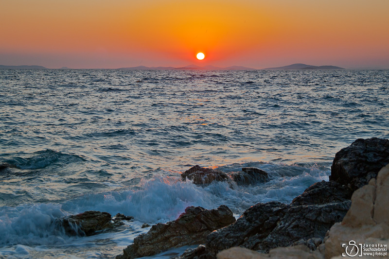
Sun, sea and rocks

Image
Dalmatia is a great place for summer holidays. Seaside landscapes are stunning and the sunsets forever remain in the memory... See also my other posts about beautiful  C roatian landscapes

Dalmatian coastline

Image
Dalmatia is a historical region of Croatia. It is a narrow belt of the east shore of the Adriatic Sea. It stretches from the town of Zadar in the north to the Bay of Kotor on the border with Montenegro in the south. The shore is the most indented coastline in the Mediterranean. The majority of the coast is characterised by a karst topography. The coast line features long offshore islands and coastal inlets that are parallel to the coastline. The sea floods elongated valleys, and as a result many bays and peninsulas take on a hammer-like form.  The long, rugged Dalmatian coast, backed by high mountains with hundreds of offshore islands, is becoming Europe's very popular vacation spot.

Fagaras Mountains - the highest mounain range in Romania

Image
Făgăraș Mountains (Romanian: Munții Făgărașului), named by Emmanuel de Martonne in 1907 „The Transylvanian Alps” are the highest mountains of the Southern Carpathians, in Romania. They are a subunit of the Southern Carpathians (Carpatii Meridionali) and are bordered by the Piatra Craiului Mountains (east), Olt Valley (Valea Oltului - west), Campulung, Bradetu and Jiblea Depression (south) and the Făgăraș Depression (north), through which the Olt river flows. Făgăraș Mountains are the Alpine-type mountains, and particularly in the central part of the band you can see their rocky nature. In the Făgăraș Mountains you can find many peaks over 2000 m asl., and many glacier lakes, e.g. Bâlea (2034 m, 46,508 m2, 11.35 m deep). The Făgăraș Mountains are a very popular hiking, trekking and skiing destination in Romania. Tourists that desire to discover the Fagaras Mountains approach this massif from the Făgăraș Depression, from Sibiu, Brașov, and Făgăraș. Route DN7C (National Road 7C
Related Posts Plugin for WordPress, Blogger...

Most Recent Articles

See Also